INDEPENDENT PROPERTY INVESTIGATIONS · DENVER METRO
Stormwater & drainage consultation Start with a $399 roadmap.
Understand your Denver-area drainage concern before committing to a broader investigation. Start with the $399 Stormwater Roadmap Consultation, or define a records and field-documentation scope.
Build a source-referenced account of the property, the changes over time and the water concerns that need answers. Technical collaboration is considered by arrangement when specialist analysis is needed.
Property records. Field observations. Clearly supported findings.
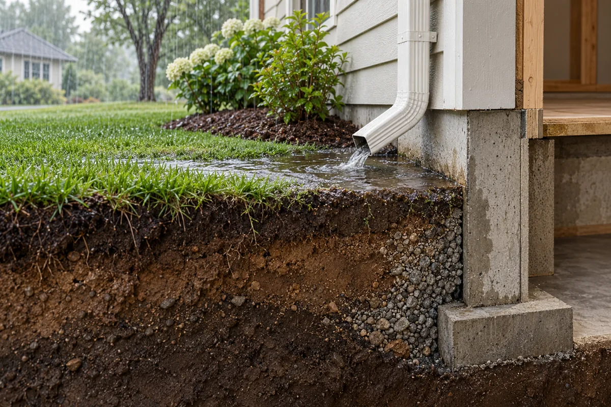
Conceptual investigation exhibit. Dashed lines are illustrative, not surveyed boundaries; arrows do not establish actual flow or causation.
Concept illustration: Conceptual cutaway showing runoff collecting beside a foundation.
Understand land and surface water movement.
Review visible drainage conditions, potential water pathways and the next steps for documenting your property.
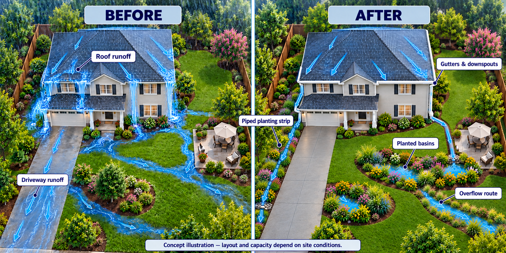
Planning the landscape around the water: roof runoff can be directed toward planted areas with defined overflow routes. Concept illustration; layout, capacity and discharge locations depend on site conditions.Explore Land & Surface Water Movement →
A DEFINED FIRST STEP · $399 ONE-TIME FEE
Stormwater Roadmap Consultation — $399
Water pooling near your foundation, runoff crossing your yard, or a downspout draining toward your property? Start with an organized review and a written plan for what to document, which records to seek and which professional to involve next.
Initial consultation
One property, one defined drainage concern, review of your supplied photos and key records, and one consultation to discuss the history and unanswered questions. The document set and meeting format are confirmed in writing before payment.
Your written roadmap
Summary of the concern and supplied evidence
Observed versus reported conditions clearly distinguished
Records and photo gaps to address
Prioritized next steps and questions for an engineer, surveyor, contractor or attorney
Defined limits
The $399 fee covers the initial consultation and roadmap. Site visits, rain-event monitoring, agency records fees, extensive research, engineering, surveying, repairs and testimony are separately scoped. This is not an engineered drainage plan, causation determination or legal opinion.
Confirm the document set, meeting format and written scope before paying. The $399 roadmap is a one-time purchase; site visits and specialist work are separate. After payment, keep your Square confirmation; we will arrange the paid consultation. A free scope call is separate and does not replace the paid roadmap consultation.
HOMEOWNER DRAINAGE QUESTIONS
Where should I start with a drainage problem?
Water pools next to my house after rain
Document when it occurs, how long it remains and the visible path from roof outlets or surrounding ground. The roadmap identifies evidence gaps and whether an on-site assessment or civil engineer is the next step.
My neighbor’s runoff comes onto my property
Bring dated photos taken from authorized areas, event dates and available plans or correspondence. We organize the factual questions without assuming the source, boundary location or legal responsibility.
Drainage changed after construction
Compare dated before-and-after records, permits if available and visible changes. A chronology helps a separately engaged professional decide what further investigation is needed.
Understand the record. Investigate the conditions.
Each engagement begins with a specific property question. The scope identifies which records will be reviewed, which areas can be observed and what the report is intended to support.
01 / RECORDS
Deed, Plat and Property-Record Research
Locate and organize available documents relevant to the investigation.
Deeds, recorded plats and supplied surveys
Recorded easement documents and references
Available permits, drainage plans and maintenance records
Source index, document dates and factual comparisons
Research and comparison; boundaries and legal rights require specialist determination
02 / FIELD CONDITIONS
Surface-Water Flow Investigation
Document accessible conditions and distinguish visible flow from inferred pathways.
Visible slopes, low areas, swales and discharge points
Accessible culverts, inlets and apparent obstructions
Pooling, erosion, sediment and water marks
Rain-event observations when separately arranged and safe
Compare available records with dated evidence of property changes.
Construction, grading and drainage alterations
Source-referenced property chronology
Baseline and repeat photo locations
Documented discrepancies and unresolved questions
Timing and associations are distinguished from proven causation
Roof runoff remains part of the picture. Gutters, downspouts and discharge conditions can be included in a broader property investigation or scoped as a focused roof inspection add-on.
The initial Stormwater Roadmap Consultation is $399. Broader investigation fees follow a scope review and written quote. Records costs, repeat visits, monitoring and specialist services are identified separately. No on-site investigation is reserved by a free call.
START WITH THE CONCERN
What are you seeing?
A starting point for your conversation. Final scope follows review.
SUGGESTED STARTING POINT
Property-Record Research and Comparison
Start with available deeds, plats, surveys and permits. Identify document dates, source references and factual differences before defining field questions.
A property investigation report. Built around its sources.
The written scope identifies the report components, intended audience and delivery format. A typical investigation file brings together:
Recorded features, present conditions and possible explanations are kept distinct. A document reference is not a field verification; an apparent flow path is not proof of storm performance.
Source index & chronologyDocument identifiers, dates, provenance, supplied accounts and a referenced sequence of relevant events.
Located field evidenceDated photos, captions, observation logs and annotated exhibits. Conceptual sketches and GIS references are labeled as non-survey information.
Findings & open questionsSupported observations, record discrepancies, interpretations with their basis, uncertainties and specialist investigation needs.
INDEPENDENT TECHNICAL COLLABORATION
A clearer handoff to the right professional.
CHC can prepare the factual investigation file and discuss coordination with a client's independently engaged professionals. Collaboration is considered by arrangement; no engineering affiliation or retained specialist is implied.
Roles are confirmed in each written engagement.
Professional role
Contribution
CHC investigation
Records organization, property chronology, visible-condition documentation and source-referenced exhibits.
Civil engineer
Separately engaged hydrologic or hydraulic analysis, capacity assessment, engineering conclusions and design when needed.
Land surveyor
Separately engaged boundary, location and elevation survey work appropriate to the investigation.
Attorney
Legal interpretation of deeds, easements, responsibilities and options for resolving disputes.
Specialist selection, scope, fees, contracting responsibility and permission to share records are agreed before coordination begins. CHC's report does not substitute for their professional work.
INVESTIGATION PROCESS
From a property question to a usable record.
Define the questionReview the property, concern, intended use, available records and access. Confirm fit and a written scope.
Establish the baselineIndex source documents and prepare a preliminary chronology and field questions.
Document the siteRecord accessible conditions and relevant changes. Repeat or rain-event visits are included only when agreed.
Connect and qualify the findingsCompare records and observations, identify gaps and deliver the agreed report. Coordinate specialist follow-up when separately authorized.
PROFESSIONAL SCOPE
Know what the assessment answers.
CHC researches property records, documents visible conditions and offers construction-focused observations. Land hydrology questions help define the investigation; engineering hydrologic analysis is separately scoped with an appropriately qualified professional. A dry-weather visit cannot establish how a site performs during a storm. Buried drains, concealed defects and conditions outside accessible areas may remain unverified.
This service does not include civil engineering design, hydrologic or hydraulic calculations, drainage-capacity certification, boundary surveying, permit approval or legal opinions. Where those are needed, the next step is a separately engaged qualified professional.
We compare recorded references without determining ownership, boundaries or easement rights. Records intended for an attorney, insurer or agency require an agreed purpose and format. Documentation does not determine fault, easement rights or claim coverage, and does not guarantee acceptance or an outcome.
COMMON QUESTIONS
Before an investigation begins.
What should I send for a records review?
Start with the property address, your question and copies of relevant deeds, plats, surveys, permits or agency correspondence you already hold. Keep original files and source information. We agree on any additional records research and costs before proceeding.
Can you determine whether a neighbor caused the problem?
We can document visible conditions on authorized, accessible areas and distinguish observed flow from reported history. Causation may require additional investigation or engineering. Legal responsibility is outside this service.
Do you inspect during a rainstorm?
Rain-event observations can be considered by arrangement when conditions and access are safe. Weather timing is uncertain. The written scope specifies any return visits and additional fees.
Can this be combined with Roof360?
Yes, a separately defined runoff review can document visible gutter and discharge conditions before or after roof work. Engineering design and concealed-system testing are outside that visual review. Explore Roof360.
Will you perform the repairs?
The assessment stands on its own. Any repair or referral is discussed separately, and you choose your provider. Repairs are not included in the documentation fee.
LET’S DEFINE THE NEXT STEP
Start with the property. Then agree on the scope.
Have the address, investigation question, relevant records, photos, event dates and any deadline in your text or email. We confirm fit, authorized access, report purpose, deliverables and a written quote before accepting paid work.
Denver and surrounding metro communities by arrangement. View service area.
Please text your inquiry or email us with your name, property address and concern. Calls are by appointment only, after we review your inquiry and confirm a time by text or email.